

Over all, we had a terrific time there speaking English, caving, SCUBA diving, making new friends, and speaking more English; it's easy to see why Belize is a popular tourist destination.
Our first stop after crossing over from Guatemala was San Ignacio, a very pleasant town half an hour from the border. We had read and heard that Belize was significantly more expensive than the surrounding countries, so we were pleased to find a hotel room for just $12.50 US a night, complete with adorable bonus pomeranians!
 The signature excursion from San Ignacio is the "ATM tour"--no, not of the nearby cash machines, but of the Actun Tunichil Muknal caving system. You can see the mouth of the cave to our left below.
 You enter the cave by swimming into it, being careful not to get the headlamp on your hard hat wet!
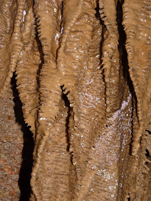
In the first portion of the cave, there's still some natural light, and you can see amazing rock formations. At the top of this picture you can see some incredible sheet stalagtites (silly me, I thought they only came in columns!). Underneath that, toward the right, is sparkly "flowstone," formed from water flowing over the rock over millenia. Very glittery in person. This one looks like a woman in a fancy dress with her back turned.

Further in: These stalagtites, in addition to looking eerily like chicken skin, can be "played" like a xylophone--you tap different ones in different places and get different tones echoing through the cave!
 Here we are in front of the xylophone.
 Even deeper inside the cave, we climbed up to a dry level to see a whole bunch of Mayan artifacts. Here I am making a scary face halfway up the climb.
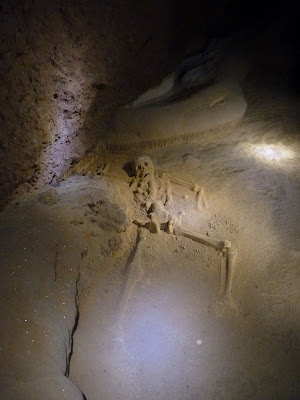
There are various remnants of pottery and other objects in the dry area, but the craziest remains are the human ones, likely from ritual sacrifices. This full skeleton of a teenage girl was placed in a dancing pose probably close to 1,000 years ago, and has been naturally preserved by the conditions in the cave.
And here is the skull of another Mayan lucky enough to get sacrificed.
 All in all, we spent about three hours in the cave; it was a wet and slightly cold experience, but beautiful and fascinating and one of my favorite excursions of our entire 6-month trip. If you ever go to Belize, I highly recommend you venture west to San Ignacio and do the ATM tour!
The next day, rain marred our canoeing trip a bit...but even rain doesn't keep the intrepid Belizean iguanas from coming out!
 When the rain did let up, Andy immediately stuck his head in a waterfall. (This may be the warmest shower we got in all of Belize.)
 Our next stop in Belize was a tiny village called Maya Center. Three dirt paths, one bodega, one (overpriced) hotel, and that's pretty much the whole place. But it is the closest town to the world's only jaguar reserve, the Cockscomb Basin Wildlife Sanctuary, and we figured that if we had any chance of spotting the elusive jaguar in our travels, this was it.
I feel it's only right to tell you immediately that we did NOT see a jaguar. In fact, we did not even see a mammal, despite spending the whole day and doing a night tour with a very knowledgeable guide. Ah, such is life.
We did see an awesome turkey at our hotel in Maya Center, though.

Andy also found some interesting fungi in the park.
 Definitely the coolest wildlife specimen our group saw in the park was this butterfly being eaten by a gekko! Check out the upside-down butterfly on top in the mouth of the long green lizard on bottom...
 The closest we came to seeing a jaguar were these prints in the mud. Our guide seemed excited and said that they were "very fresh" and that we'd "just missed one," but after he'd said that about three different specimens, I began to grow sceptical.
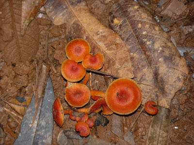
Meanwhile, Andy continued to take pictures of those less-elusive creatures, colorful mushrooms.
 While our tour-mates returned to Maya Center for the night, Andy and I decided to rough it in an unelectrified cabin at the park HQ, thereby giving ourselves a little more time to see absolutely no big cats whatsoever.
We did an extra hike that turned out to be way longer than the map indicated, leaving us racing against the sunset to make it back to the cabin before total darkness fell. On the hike, we did see some pretty vistas, like this ferny area...

...and we found a nice white-backed lizard. (Maybe they should rename this place the Cockscomb Lizard and Insect Sanctuary?)

Speaking of insects, the worst thing about the wildlife reserve was the bugs. Repeatedly dousing ourselves in DEET did nothing to keep the mosquitoes and even more voracious botflies at bay, and we were scratching for a week after our visit. (Then, a few weeks later, back in the USA, I got an awesome botfly-related surprise...stay tuned for a blog post coming soon about that adventure!)
The best thing about going there were the new friends we made, Mandi and Tommy. We met them on the bus to Maya Center (we were the only four gringos intrepid enough to go stay there rather than take a package tour to the jaguar reserve from a more touristy beach town), banded together to hire a tour guide and collectively bargain for better prices at the usurious hotel, played hearts and euchre until late in the night, and just generally got on swimmingly together. We were very happy to learn that they were heading to the same sandy island (Caye Caulker) as we were next, so we met up with them again for two great meals and to dominate at trivia night! But I get ahead of myself.
So, after a dark and quiet night in the park, Andy and I walked the seven miles from Coxcomb Basin HQ to the bus stop in Maya Center. We could have paid for a taxi, but we were hoping that if we walked we might see some cool animals along the dirt road. FAIL. Ah well, at least it was exercise.
We then took a bus to Belize City, and from there got on the water taxi ferry boat to Caye Caulker, one of Belize's many islands along its barrier reef out in the Atlantic. History seemed to repeat itself when we found a beach cabin for just $12.50 that also came with its own bonus animal, this time a corner-dwelling lizard.

The cabin was mildly crappy (I know, I know, what do you expect for $12.50?) but the grounds did feature this nifty plant that made Andy look like a peacock when he posed with it.

Andy's and my main reason for going to Caye Caulker was to go SCUBA diving, which we had learned to do almost two years earlier but had not attempted since our qualifying dives. I was a little scared and made Andy do a refresher course and practice dive with me before we went out to the reef, but it was totally worth it because the diving was amazing.
We couldn't take pictures at such depths, but I can report that we saw a whole eel swimming (a rare sight as they're usually tucked into their holes and just poke their heads out), an enormous eagle ray, several nurse sharks, some huge lobsters, plenty of colorful fish and coral...and the highlight of my diving career thus far, a turtle taking a poop as it swam.
We also did some snorkeling right off the beach on Caye Caulker, and Andy got some great shots with the waterproof camera. Here is a lovely blue fish...

a nifty stripey one...

...and an enormous puffer or boxfish that Andy found hiding out under the pier. It took many dives, but he got a pretty good shot of the fish here!

On our last night on Caye Caulker, Andy and I teamed up with Mandi and Tommy to take the local pub quiz by storm. Forming Team "The Bicoastal Badasses"--our new friends are Californians--we won first prize, or 50 Belizean dollars off our bar tab. (Too bad our tab was only $14...Mandi and I just couldn't bring ourselves to order more than one round of "panty rippers," surely the most unappetizing name anyone could ever invent for the otherwise tasty tropical standby of Malibu-and-pineapple!)
 The next morning, the weather on the island was perfect as we boarded the water taxi to return to Belize City.
And apparently, in Belize City, on the final day of our trip, we did nothing but eat, since I have no pictures of anything else to share here. You'll have to check back in for Andy's forthcoming food post!
Belize was a nice place to wrap up this leg of our travels. If you're thinking about going there, San Ignacio and Caye Caulker are terrific, and Belize City is worth a visit, not nearly as bad as most people make it out to be. I might skip the jaguar reserve, unless you really like lizards and being eaten alive by insects, but who knows...I guess you could get lucky and see a cat.
Or get even luckier and bring home an exotic, living souvenir or two in your scalp!
Say what?
Yeah, more on that in the next post. =)


